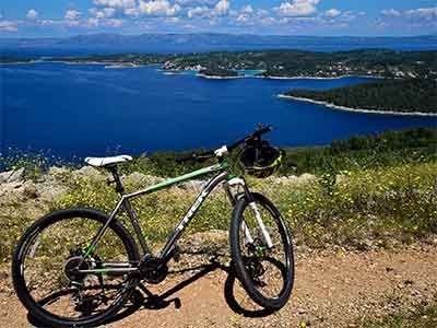
bike routes
worth cycling
Discover the island that boasts rich cultural and historical heritage and stunning landscapes and take a walk in the footsteps of the great explorer Marco Polo in our Great Island Bike Challenge.
Korčula bike routes description
THE GREAT ISLAND BIKE CHALLENGE
EXPLORE KORČULA
Discover the island that boasts rich cultural and historical heritage and stunning landscapes and take a walk in the footsteps of the great explorer Marco Polo in our Great Island Bike Challenge. You can start from wherever it’s convenient for you depending on the location of your accommodation. Explore interesting towns and villages of the island of Korčula and visit beaches and lookout points that are often hidden, but surprisingly easily accessible. Don’t miss out on the popular tourist attractions such as churches, the gems of the historical heritage of the island.
Technical specification:
Length: a 131-kilometre circular cycling route
Terrain: 91.2 km of asphalt roads (70%); 39.8 km of gravel roads (30%)
Altitude: +2245/-2244
Start point/end point: the town centre of Korčula (or the location of your accommodation)
Towns and villages on route: Korčula – Medvinjak – Žrnovska Banja – Kneže – Račišće – Babina – Prigradica – Bristva – Črnja Luka – Vela Luka – Potirna – Zaglav – Karbuni – Grščica – Prižba – Brna – Smokvica – Zavalatica – Čara – above Pupnatska Luka – Pupnat – Postrana – Lumbarda – Korčula
Expected duration: a one-day tour for physically fit cyclists
Note: a multi-day tour is also possible
Markings: none (GPX file available for DOWNLOAD)
Locations of self-service bike repair stations with a fixed stand and basic tools: Babina bay, archaeological site Vela spila in Vela Luka, Morkan-Blato-Smokvica T intersection, above Pupnatska Luka, rest area between the village of Lumbarda and the town of Korčula.
About the route:
This route starts at Trg Pomirenja square in the centre of the town of Korčula, passes through the settlements of Medvinjak, Žrnovska Banja and Kneže and takes you to Račišće, a village some 12 km from Korčula. From there, it follows the coast along a demanding gravel road section (9.2 km) to Babina. The gravel road, partially interrupted with paved road sections, is damaged on certain steep slopes (where caution is required when riding). The last gravel road ascent before the village of Babina is especially steep and demanding.
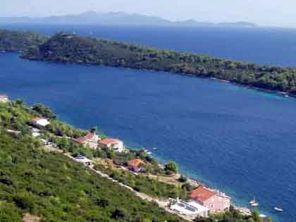
From Babina, the route follows a paved road along the bays of Rasoha, Blaca and Žukova all the way to Prigradica. From Prigradica bay, it continues along the coast to Bristve, which todays serves as a slipway for the shipyard of Radež, until the bay of Črnja Luka.
Leaving the coast behind, the route will take you on a gradual climb to the most important archaeological site at the Mediterranean know as Vela spila, a system of caves more than 20,000 years old. It then continues downhill along a gravel road, which later turns into an asphalt road, and enters Vela Luka from the north.
Following Vela Luka bay, the route will take you to the bays of Poplat, Gabrica, Pičena and Lučica where, after a few gravel road sections, it turns into an asphalt road. The road ascends towards the pass below Hum hill (380 m) where an Austro-Hungarian fort is located and descends towards Potirna, from where a gravel road will take you to Zaglav bay.
From there, the route follows the coast again and offers stunning views of the island of Lastovo and numerous islets, with Zvirinovik located just across the settlement of Karbuni being the largest among them. A gravel road with 3.4 km in length will take you from Karbuni to the bay of Gršćica, and then along the coast through the village of Prižba, nestled between the two peninsulas, Ratak and Prišćapac, to the bay and village of Brna, followed by an ascent to the fertile and wine-growing region known as the cradle of pošip wine variety – the village of Smokvica. Just before entering the village, you can either continue straight down the road toward the centre of the village, home to the parish Church of the Purification of the Blessed Virgin Mary with a loggia or continue following the route by taking the right turn south of the village through the field of Prapratna. From the village of Smokvica, through the field of Prapratna, where the remains of Kanavelić tower and the Church of St Ann (14th century) are located, the route takes you on a descent down the moderately preserved gravel road (1.5 km in length) to the bay and the village of Zavalatica.
It is possible to get off the route after the field of Prapratna in the direction of Pinćaluša – a monument to pošip grape variety (a 1.3 km ascent on a paved road).
From Zavalatica, the route follows a steep uphill asphalt road, which later turns into a picturesque road through the fertile and wine-growing field in the direction of the village of Čara, passing by the largest island sanctuary i.e. the Church of Our Lady in the Field (14th century) and, through vineyards and pine forests, reaching the bay of Pupnatska Luka.
Next is a 7-kilometre long road ascent in the direction of the village of Pupnat that will take you just below the huge, impressive stone formation of Riče. The route turns right off the D118 road (after 1.5 km) after Pupnat towards Bačva bay. The condition of the gravel road surface on this part of the route (in the direction of Bačva bay) until the hamlet of Postrana in Žrnovo varies from preserved to moderately preserved followed by a 400-metre steep concrete road section until Konoba Maha (6.8 km). The condition of the gravel road surface in the area between the turn for Rasohatica bay until the road exit next to the Kokojevica landfill is preserved to moderately preserved (2.8 km).
From there, the route takes you to the easternmost point of the route, the village of Lumbarda and the famous Pržina beach. It follows the road through vineyards, passes by the Church of the Holy Cross located in the centre of the roundabout and continues all the way to the centre of the town. It turns right from the Lumbarda-Korčula main road and continues through the karst field of Donje blato (gravel road with 2.6 km in length), the pine forest and dry stone walls. From there, it follows the road next to the lookout point of the Votive Chapel of St Anthony, locally known as Glavica, featuring row of cypress trees, and then, along Šetalište Tina Ujevića promenade, below the Hober forest part, returns to its starting point in the centre of the town of Korčula. Congratulations! You have joined one of the million explorers of the island of Korčula, inspired by the most famous western explorer who travelled the Silk Road from Europe to China and wrote the famous travelogue The Travels of Marco Polo. Who knows, maybe you will write a book about your own Korčula explorations!
Emergency contacts:
In case of emergency call 112.
Tourist Boards:
Town of Korčula: +385 20 715 701
Municipality of Lumbarda: +385 20 712 005
Municipality of Smokvica: +385 20 832 255
Municipality of Blato: +385 20 851 850
Municipality of Vela Luka: +385 20 813 619
RIDING IN THE SHADE OF PINE, CYPRESS AND OLIVE TREES ALL THE WAY TO THE EASTERNMOST POINT OF THE ISLAND
Technical specification:
Length: a 22.4-kilometre circular route
Terrain: 17.4 km of asphalt roads (78%); 5 km of gravel roads (22%)
Altitude: 350 m
Start point/end point: centre of the town of Korčula
Towns and villages on route: Prvo selo – Žrnovo – Kampuš – Postrana – Lumbarda - Korčula
Expected duration: 2 hours 30 minutes
Difficulty: 2/5
Note:The section between Potirna and Zaglav features a slightly more demanding gravel road passing through forests and dry stone walls (3.3 km in length).
Markings: none (GPX file available for DOWNLOAD)
Locations of self-service bike repair stations with a fixed stand and basic tools: rest area at Korčula – Lumbarda road.
Starting in the centre of the town of Korčula, this circular route will take you on a journey along winding scenic areas of the village of Žrnovo and its hamlets Prvo selo, Kampuš and Postrana. It features interesting detours for exploring natural and historical sites, lighthouses and beaches, forts and churches with spectacular views of the surrounding area and it offers some quality R & R in local family farms and coffee shops in the centre of villages. The last section of the route offers a pleasant downhill ride through stunning olive groves, wine-growing hillsides and the field of Lumbarda famous for its numerous stone fences i.e. dry stone walls and sandy beaches only to return, through the karst field of Donje blato and pine forests, following the coastal promenade, to the historic, artistic and architectural gem of the island, the town of Korčula.
About the route: Starting at Trg Pomirenja square in Korčula, immediately after passing the coastal streets of Put Svetog Nikole and Strečica, the route turns sharply to the left and continues along the uphill forested, scenic road below the Forteca fort, which features breath-taking views of the old town of Korčula.
The route continues until the intersection with the main road D118 and after 400 m, it turns right onto the remains of the marked Marmont Path and passes through Prvo selo, Žrnovo, Kampuš and Postrana which safeguard numerous valuable natural, cultural and historical heritage, especially religious buildings.
In the hamlet of Postrana the route follows a well preserved and moderately preserved gravel road (approx. 2.8 km) in the direction of Rasohatica bay and Lumbarda. It passes through vineyards and olive groves, switching between asphalt and gravel roads, and takes you to Lumbarda and the sandy beach of Pržina, with stunning views of open seas and the island of Mljet. We suggest you get off the route and head towards the lighthouse on Ražnjić cape (1.2 km), the easternmost point of the island with stunning views of the imposing Sveti Ilija (961 m), the highest peak of the Pelješac peninsula. From there, the route continues through vineyards, passing by the Church of the Holy Cross in the centre of the roundabout, and soon afterwards it provides a detour towards the parish Church of St Rocco and the centre of the village. Leaving Lumbarda, the route turns right from the asphalt road into a gravel road through the karst field of Donje blato. It continues through the pine forest and dry stone walls, passes by the lookout point of the Votive Chapel of St Anthony, locally known as Glavica, featuring a row of cypress trees, and then, along Šetalište Tina Ujevića promenade, below the Hober forest part, returns to its starting point in the centre of the town of Korčula.
Emergency contacts:
In case of emergency call 112.
Tourist Boards: Town of Korčula: +385 20 715 701
Municipality of Lumbarda: +385 20 712 005
WHERE THE COASTAL AND HINTERLAND SCENERY OF THE PICTURESQUE ISLAND OF KORČULA INTERTWINE
Technical specification:
Length: a 61.1-kilometre circular route
Terrain: 51.9 km of asphalt roads (85%), 9.2 km of gravel roads (15%)
Altitude: 880 m
Start point/end point: the promenade in the centre of Prigradica
Towns and villages on route: Prigradica-Blato-Smokvica-Čara-Pupnat-Kneže-Račišće-Babina-Prigradica
Expected duration: 6 hours
Difficulty: 5/5
Note:The section between Potirna and Zaglav features a slightly more demanding gravel road passing through forests and dry stone walls (3.3 km in length).
Markings: none (GPX file available for DOWNLOAD)
Note:Due to a narrow winding road with an extremely steep downhill, the Pupnat - Kneže (5 km) section requires additional caution, while the 9.2-kilometre Račišće – Babina section features a gravel road with several shorter, but steeper ascents and descents.
Locations of self-service bike repair stations with a fixed stand and basic tools: Babina Bay, Morkan-Blato-Smokvica T-intersection and a spot above Pupnatska Luka..
Starting in Prigradica bay, this circular route will take you along the road from the promenade towards Blato, a village in the hinterland of the island that features a vast field and the famous dry stone wall terraces. From there, it continues to Smokvica and Čara, often regarded as the homeland of pošip grape variety. The route climbs the road above the bay and beach of Pupnatska Luka all the way to Pupnat, the smallest and one of the oldest settlements on the island. Returning to the northern coastal part of the island along the steep descent on a winding road to the bay and village of Kneže, the route continues along the coast to the village of Račišće, where it follows the gravel road next to beaches of Vaja and Samograd all the way to Babina bay. From there, it takes an asphalt road passing by picturesque and peaceful bays of Rasoha and Blaca and ends in Prigradica.
About the route: Starting in Prigradica, the route winds along the coast and immediately continues up the uphill road towards Blato. After the pass, the road descents and crosses the busy D118 road via an overpass next to the Blato Cemetery of the Holy Cross and through two roundabouts before taking the winding ascent in Prižba direction.
We recommend you get off the route and follow the famous Zlinje Street, featuring a linden tree avenue, which will take you to the centre of Blato and visit the spacious square in front of the parish Church of All Saints with a loggia.
The route continues up the uphill road in Prižbe direction, turns left off the main road at the third large bend and takes you to the pass which marks the beginning of a descent along the olive groves and vineyards all the way to the entrance of Smokvica, the cradle of the famous white wine variety pošip.
In addition to numerous wine tasting rooms, don’t miss out on the parish Church of the Purification of the Blessed Virgin Mary (17th century). Passing through the fertile fields of Smokvica and Čara, the route takes you to the centre of the village of Čara where a cypress tree, a protected natural monument believed to be over 350 years old, can be found next to the parish Church of St Peter (17th century). Visiting wineries with tasting rooms serving quality and top wines, with pošip being the featured wine in Čara, is a must. The route continues through vineyards, olive groves and pine forests passing the bay of Pupnatska Luka and large rock formation of Riče and after a 7-kilometre ascent enters the village of Pupnat, home to the parish Church of Our Lady of the Snows from the 17th century. Moving on, a narrow, steep and winding road takes you to the village of Kneže and from there the route continues along the coast to Račišće. It passes through the picturesque fishing and maritime village, next to the parish Church of St Nicholas (20th century), the patron saint of sailors, and the older Church of Our Lady Help of Christians (from the end of the 17th century). From there, a more demanding but tranquil gravel road offering panoramic views of the islands and the open sea will take you to Babina bay, Rasoha bay and the village of Blaca and end in Prigradica.
Emergency contacts:
In case of emergency call 112.
Tourist boards:
Municipality of Blato: +385 20 851 850
Municipality of Smokvica: +385 20 832 255
Town of Korčula: +385 20 715 701
FROM BLATO FIELD TO VELA LUKA BAY AND THE INDENTED SOUTHERN COAST OF THE ISLAND OF KORČULA
Technical specification:
Length: a 48.1-kilometre circular cycling route
Terrain: 32.3 km of asphalt roads (67%), 15.8 km of gravel roads (32%)
Altitude: 870 m
Start point/end point: the centre of the town of Blato
Towns and villages on route: Blato - Črnja Luka - Vela Luka – Zaglav - Karbuni – Gršćica - Prižba – Blato
Expected duration: 4-5 hours
Difficulty: 5/5
Note:The section between Potirna and Zaglav features a slightly more demanding gravel road passing through forests and dry stone walls (3.3 km in length).
Markings: none (GPX file available for DOWNLOAD)
Locations of self-service bike repair stations with a fixed stand and basic tools: archaeological site of Vela spila and Morkan-Blato-Smokvica T-intersection.
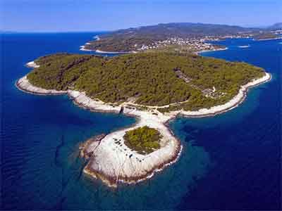
This route starts in the village of Blato. Stretches of ascents and fields, extremely indented southern coast with numerous islets and the peninsulas of Ratak and Prišćipac abound along this route. What makes this route special are the views of small rocky and forested islets surrounding Vela Luka. The fantastic scenery consisting of a plethora of smaller and larger bays of the indented coast, dotted with vineyards, olive groves and fragrant pine forests along the flatter terrain of the southern coast of the island of Korčula protected by a string of islets from Zaglav to Prižba make it a great ride for all cycling enthusiasts.
What are you waiting for? Embark on a journey where natural attractions meets tradition, customs, flavours and scents of the island.
About the route:
Starting in the centre of Blato, a village located in the heart of the largest fertile field on the island of Korčula, this circular route takes you in the direction of Prigradica on the northern side of the island. After Blato, the route briefly follows the state road D118 (700 m in length), after which it turns right and follows the uphill road to a pass from where it continues downhill towards the villages of Bristva and Črnja Luka.
Before Bristva, the route takes a left turn to Črnja Luka bay from where it continues along the coastal gravel road. The condition of the gravel road surface ranges from preserved to moderately preserved and is occasionally interrupted with asphalt and concrete sections (8.1 km).
The route will take you to the town of Vela Luka passing next to the renowned archaeological site on the island known as Vela spila. The route continues to the centre of Vela Luka, first along the preserved gravel road (1.0 km in length) and then down a winding and narrow stretch where caution is required. After Vela Luka, the route continues in the direction of the southern part of the island along the busy 41st Street from which it takes a left turn towards Potirna and, after the ascent, a left turn on the gravel road north of Zaglav bay. This moderately preserved gravel road will reward you with a 3.3 kilometre downhill slope to Zaglav bay. From there, the route continues along the coast where asphalt and gravel road sections interchange. The preserved gravel road of Karbuni – Gršćica section features a pleasant ride in the shade of pine forests. Once you pass through the village of Gršćica, the route takes you to the hamlet of Prižba on the peninsula of Ratak and offers amazing views of the string of islets all the way to the peninsula of Prišćipac. In Prižba, the route splits into two different sections. If you choose the section heading left, the route continues uphill towards Blato through picturesque olive groves and vineyards of the Morkan area, followed by a 7-kilometre demanding ascent until T intersection from where a descent to the left towards Blato begins, which marks the end of our route. If you choose the section heading right, you will arrive at the village of Smokvica.
Emergency contact:
In case of emergency call 112.
Tourist boards:
Municipality of Blato: +385 20 851 850
Municipality of Vela Luka: +385 20 813 619
SPLIT-POTOMJE
FROM DIOCLETIAN TO MARCO POLO
This alternative 47-km-long section will challenge you to go on a bicycle ride across the entire island of Korčula from west to east on local roads with many elevations and descents.
Visit web site
HAVE A FUN AND ENJOY IN CYCLING
KORČULA BIKE ROUTES INTERACTIVE MAP
bike routes
vela luka
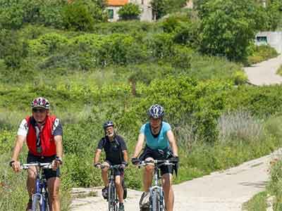
Exploring island of Korčula on a bicycle is a unique experience. The island is full of hilly roads that curve in different landscapes of Vela Luka surroundings, as well as on the rest of the island. Bear in mind that these cycling routes are not meant for bicycles only. A network of side roads, gravel roads and trails is used by others – cars on the road, agricultural workers on gravel roads and hikers on hiking trails. Therefore, we ask you to keep safe and respect other participants in traffic. We have chosen four routes for you that will allow you to explore in detail the west side of the island.
bike routes
blato
Exploring island of Korčula on a bicycle is a unique experience. The island is full of hilly roads that curve in different landscapes of Vela Luka surroundings, as well as on the rest of the island. Bear in mind that these cycling routes are not meant for bicycles only. A network of side roads, gravel roads and trails is used by others – cars on the road, agricultural workers on gravel roads and hikers on hiking trails. Therefore, we ask you to keep safe and respect other participants in traffic. We have chosen four routes for you that will allow you to explore in detail the west side of the island.
bike routes
brna-smokvica
Around Brna you will find many hiking and cycling routes that will take you through picturesque countryside, pine forests, olive groves and vineyards to views, caves and beautiful bays.
bike routes
lumbarda
Lumbarda offers you the perfect opportunity for an active vacation. Among the many activities you can choose cycling along beautiful nature trails.
bike routes
worth to cycle
Explore our beautiful and romantic island and its coves extending along the north coast as far as Račišće, a picturesque resort with a centuries-old maritime tradition; and don't miss the fascinating settlements at the heart of the island: Žrnovo, Pupnat and Čara. From Zrnovo, the birthplace of our well-known writer Petar Šegedin, head South to reach cosy coves with gravel beaches, surrounded by fragrant Mediterranean vegetation. Walking on the paths through the olive groves or by the sea, you can taste, in local houses and taverns, various kinds of olive oil, honey and other ecological products.
The fertile plain, Čarsko Polje, is the home of the best Pošip, a well-known white wine, which you can taste in one of Čara wineries. From the smallest settlement of the island, Pupnat, you can reach by coast road towards Čara, the biggest pebble beach on the island called Pupnatska Luka.